
UPSC Current Affairs October 30, 2026: ISRO Launches NVS-03 Satellite Aboard GSLV-F18 | Atharva Examwise Current News, Daily GK Update & Competitive Exam News Today
Executive Summary: Strengthening India's Space and Time Sovereignty
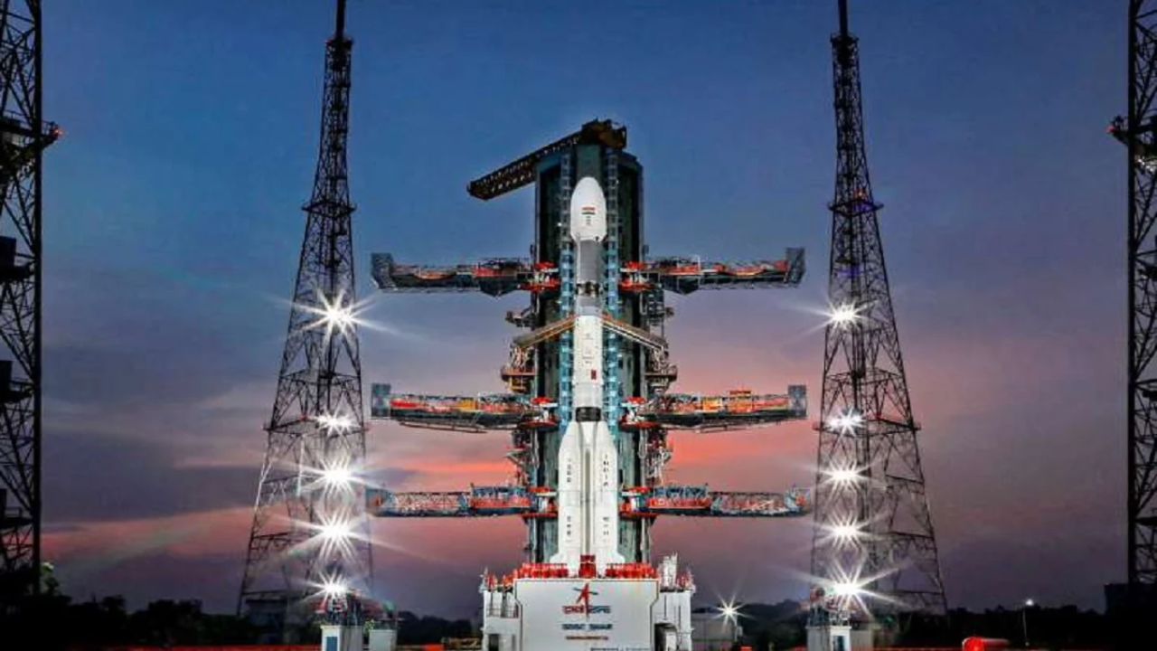
In a defining milestone dominating current affairs October 30, 2026, the Indian Space Research Organisation (ISRO) is scheduled to launch its third second-generation navigation satellite, NVS-03, aboard the GSLV-F18 launch vehicle at 23:51 hrs IST (11:51 PM) from the Second Launch Pad (SLP) at the Satish Dhawan Space Centre (SDSC SHAR) in Sriharikota, Andhra Pradesh. Weighing 2,232 kg at liftoff—within the nominal 2,250 kg payload class—the NVS-03 spacecraft is engineered to ensure service continuity and expand the operational capabilities of India's autonomous regional navigation architecture, the Indian Regional Navigation Satellite System (IRNSS), operationally designated as Navigation with Indian Constellation (NavIC).
For civil services aspirants tracking UPSC current affairs and competitive exam news today, this mission represents far more than a routine orbital insertion. Coming twenty-one months after the orbital-raising setback of its predecessor, NVS-02, in January 2025, the GSLV-F18/NVS-03 mission serves as a high-stakes validation of ISRO's institutional failure-recovery protocols, indigenous atomic timekeeping architecture, and commercial L1-band frequency expansion. By delivering uninterrupted Position, Velocity, and Timing (PVT) services across the entire Indian landmass and an extended strategic perimeter stretching 1,500 km beyond India's geopolitical boundaries, NVS-03 directly reduces national reliance on foreign Global Navigation Satellite Systems (GNSS) while fortifying India's sovereign digital public infrastructure. Aspirants can track related technological developments through the Atharva Examwise Current Affairs Portal.
Key Mission Facts & Prelims Data Matrix
In accordance with the rapid-revision framework of Atharva Examwise daily GK update modules, the core factual parameters and exam-relevant data points of the GSLV-F18 / NVS-03 mission are structured below for UPSC Prelims, State PCS, and Defence examinations:
Key Facts
Mission Designation: GSLV-F18 / NVS-03 Mission.
Launch Date & Time: October 30, 2026 (Friday) at 23:51 hrs IST (11:51 PM IST).
Launch Complex: Second Launch Pad (SLP), Satish Dhawan Space Centre (SDSC SHAR), Sriharikota, Andhra Pradesh.
Launch Vehicle Milestone: 20th operational flight of India's Geosynchronous Satellite Launch Vehicle (GSLV).
Target Injection Orbit: Geosynchronous Transfer Orbit (GTO).
Satellite Mass & Engineering Centres: 2,232 kg exact launch mass (2,250 kg nominal class), built by the U. R. Rao Satellite Centre (URSC) and payload-integrated by the Space Applications Centre (SAC).
Exam-Relevant Data
Constellation Sequence: Third spacecraft in the second-generation NVS series (NVS-01 to NVS-05) and the 12th satellite overall in the IRNSS/NavIC constellation.
Service Coverage Area: Complete Indian landmass plus an extended perimeter of 1,500 km beyond India's geopolitical borders.
Payload Configuration: Navigation Payload operating across L1, L5, and S frequency bands alongside a dedicated Ranging Payload.
Atomic Clock Distinction: Carries an indigenous Rubidium atomic clock developed by SAC-ISRO alongside procured atomic clocks, placing India among an elite group of five nations deploying domestic Rubidium atomic clocks in navigation satellites.
Upcoming Pipeline: NVS-04 and NVS-05 are currently under advanced realization to complete the five-satellite second-generation fleet.
| Parameter / Dimension | First-Generation IRNSS (NavIC 1.0) | Second-Generation NVS Series (NVS-03 / NavIC 2.0) | Exam-Relevant Strategic Impact |
|---|---|---|---|
| Satellite Series | IRNSS-1A to IRNSS-1I | NVS-01, NVS-02, NVS-03, NVS-04, NVS-05 | Ensures uninterrupted replacement of aging first-generation satellites. |
| Operating Frequency Bands | Dual-Band: L5 Band and S Band | Tri-Band: L1 Band, L5 Band, and S Band | Addition of civilian L1 band enables mass-market smartphone and IoT compatibility. |
| Atomic Clock Architecture | Procured Foreign Atomic Clocks | Indigenous Rubidium Atomic Clock + Procured Clocks | Eliminates critical foreign supply-chain vulnerability and establishes time sovereignty. |
| Service Categories | Standard Positioning Service (SPS) & Restricted Service (RS) | Upgraded SPS & Enhanced-Encryption RS | Bolsters anti-spoofing and secure communication for strategic defense forces. |
| Primary Coverage Footprint | India + 1,500 km beyond borders | India + 1,500 km beyond borders | Continuous all-weather surveillance across the Indian Ocean Region and continental frontiers. |
Technical Deep Dive: Payloads, Tri-Band Signals, and Indigenous Time Sovereignty
A rigorous examination of the NVS-03 spacecraft demonstrates how ISRO is systematically resolving the technological bottlenecks that historically constrained the commercial and strategic expansion of first-generation IRNSS satellites. Aspirants studying foundational physics and orbital mechanics through the Atharva Examwise Complete NCERT Foundation Course can directly link these payload upgrades to electromagnetic spectrum allocation and high-precision chronometry.
The L1 Frequency Band Breakthrough and Mass-Market Adoption
First-generation NavIC satellites transmitted navigation signals exclusively in the L5 band and S band. Because global civilian navigation hardware—particularly smartphone chipsets, automotive navigation units, and compact consumer electronics—was overwhelmingly standardized around the legacy GPS L1 frequency band, hardware manufacturers required specialized, higher-cost radio-frequency receivers to process India's L5 and S signals. By integrating the interoperable L1 civilian signal alongside the existing L5 and S bands on NVS-03, ISRO eliminates this commercial adoption barrier and positions the Indian Regional Navigation Satellite System for widespread integration into mass-market mobile and wearable devices. Furthermore, this tri-band transmission capability supports high-precision location sensing for next-generation telecommunications, directly complementing the spatial-tracking objectives examined in the Atharva Examwise Bharat 6G Vision 2030 Analysis.
Indigenous Rubidium Atomic Clocks and Time Sovereignty
Satellite navigation depends on measuring the exact time-of-flight of radio signals traveling from multiple satellites to a receiver on Earth, meaning that micro-level drift in satellite timekeeping degrades positional accuracy on the ground. Whereas early IRNSS spacecraft relied entirely on imported atomic clocks, NVS-03 carries a highly stable, indigenously developed Rubidium atomic clock engineered by the Space Applications Centre (SAC) alongside procured atomic clocks. This deployment places India's third domestic atomic clock in orbit, making India one of only five countries in the world capable of deploying indigenous Rubidium atomic clocks in navigation satellites. Beyond geographical positioning, operating sovereign spaceborne atomic clocks secures India's "time sovereignty"—an essential requirement for synchronizing national power grids, telecommunications networks, high-frequency financial systems, and strategic defense operations without relying on foreign time servers.
Dual-Service Architecture and Upgraded Military Encryption
To balance commercial accessibility with national security imperatives, NVS-03 operates two distinct navigation streams under all weather conditions. The Standard Positioning Service (SPS) provides unencrypted, open-access navigation signals to civilian, commercial, and aviation users across the Indian landmass and the 1,500 km extended boundary. Simultaneously, the Restricted Service (RS) delivers an encrypted navigation signal reserved exclusively for authorized military and strategic agencies. In the second-generation NVS series, ISRO has incorporated an upgraded cryptographic encryption framework into the Restricted Service payload, hardening India's military navigation and communication channels against electronic jamming and adversarial spoofing.
From NVS-02 Failure to NVS-03 Recovery: Engineering Root-Cause Analysis
Understanding the strategic urgency of the October 30, 2026 launch requires examining the operational failure of its immediate predecessor, NVS-02, which lifted off on January 29, 2025 aboard the GSLV-F15 rocket. In a standard GSLV mission profile, the launch vehicle places the satellite into an elliptical Geosynchronous Transfer Orbit (GTO), after which the spacecraft must fire its own onboard liquid-fuelled engine across multiple orbit-raising manoeuvres to reach its final circular operational orbit. During the January 2025 flight, GSLV-F15 successfully injected the 2,250-kg NVS-02 spacecraft into its planned initial elliptical transfer orbit of $170\text{ km} \times 37,785\text{ km}$, and its solar panels deployed nominally. However, NVS-02 became stranded in that elliptical transfer orbit when its onboard liquid-fuelled engine failed to ignite during the scheduled orbit-raising burn.
A post-flight investigation conducted by an ISRO Apex Committee through spacecraft telemetry traced the anomaly to an electrical disruption at the pyro valve—an explosive-triggered isolation valve responsible for opening the liquid fuel and oxidizer lines required to fire the onboard engine. Detailed fault analysis revealed that at least one electrical contact within both the main and redundant electrical connector paths had physically disengaged, severing the electrical circuit and preventing the firing signal from reaching the pyro valve despite built-in backup systems. Following the Apex Committee's diagnostic findings, ISRO implemented stringent corrective measures across spacecraft harness and connector verification prior to clearing NVS-03. The NVS-03 satellite arrived at the Satish Dhawan Space Centre and was ready by August 14, 2026, with the formal launch campaign commencing on September 14, 2026 and first-stage rocket stacking concluding on September 21, 2026 ahead of the October 30 liftoff. Aspirants studying spacecraft propulsion and attitude control physics can review related orbital mechanics in the Atharva Examwise Aerospace Thruster & Attitude Control Analysis.
Global & Regional Navigation Systems: How NavIC Compares with the World
A central analytical theme in UPSC Civil Services Examinations involves comparing India's space architecture against international counterparts. Globally, satellite navigation infrastructures are divided into four global constellations and two regional systems:
| System Name | Country / Entity | Operational Scope | Orbital Architecture & Altitude | Constellation Distinction |
|---|---|---|---|---|
| NavIC (IRNSS) | India (ISRO) | Standalone Regional (India + 1,500 km) | High Orbits (Geostationary & inclined Geosynchronous) | World's only independent standalone regional navigation system. |
| QZSS | Japan | Regional Augmentation (Asia-Oceania) | High Orbits (Quasi-Zenith high orbits) | Four-satellite system designed primarily to augment GPS signals. |
| GPS | United States | Global (GNSS) | Medium Earth Orbit (MEO) ($19,000\text{ to }24,000\text{ km}$) | Legacy global navigation standard operating in MEO. |
| GLONASS | Russia | Global (GNSS) | Medium Earth Orbit (MEO) ($19,000\text{ to }24,000\text{ km}$) | Global MEO constellation. |
| Galileo | European Union | Global (GNSS) | Medium Earth Orbit (MEO) ($19,000\text{ to }24,000\text{ km}$) | Global MEO navigation architecture. |
| BeiDou | China | Global (GNSS) | Hybrid Architecture (MEO at $19,000\text{–}24,000\text{ km}$ + High Orbits) | Only global system combining MEO satellites with higher-altitude orbits. |
As this structural comparison demonstrates, India is the only country in the world operating a standalone regional satellite navigation system. While Japan's four-satellite Quasi-Zenith Satellite System (QZSS) also places all of its spacecraft in high orbits, QZSS functions as an augmentation system that enhances GPS signal availability across the Asia-Oceania region rather than providing independent regional autonomy. Furthermore, among the four global constellations, every system except China's BeiDou deploys satellites exclusively in Medium Earth Orbit (MEO) at altitudes between $19,000\text{ km}$ and $24,000\text{ km}$, whereas BeiDou utilizes a hybrid combination of MEO and higher-altitude orbits. Because NavIC satellites operate in high geostationary and geosynchronous orbits, they remain continuously visible over the Indian subcontinent, prompting ongoing strategic policy discussions regarding the potential future expansion of IRNSS coverage. For primary technical documentation on the launch vehicle and orbital profile, aspirants may consult the Official ISRO GSLV-F18 / NVS-03 Mission Portal.
Why this matters for your exam preparation
Integrating this daily GK update into structured civil services preparation requires mapping the GSLV-F18 / NVS-03 mission across the UPSC Civil Services Examination (CSE) and State PCS (including MPPSC, BPSC, and RPSC) syllabi. Under the concept-first pedagogical framework established by Dr. Ajay Bhamoliya at Atharva Examwise, aspirants must synthesize both the objective technical parameters for Preliminary screening and the broader geopolitical and technological implications for Mains answer writing.
Direct UPSC Prelims Linkage (General Studies Paper-I: Science & Technology)
In the UPSC Preliminary Examination, Science and Technology questions frequently test candidate precision on orbital regimes, electromagnetic frequency bands, and indigenous hardware milestones. Aspirants utilizing the Atharva Examwise Study Material, Mind Maps & PYQ Repository should pay particular attention to comparative orbital mechanics. Specifically, examiners often construct statement-based questions contrasting Medium Earth Orbit (MEO) constellations ($19,000\text{ to }24,000\text{ km}$) against high-orbit systems like NavIC and Japan's QZSS, as well as testing the distinction between India's standalone regional architecture and Japan's GPS-augmentation model. Equally important for Prelims recall is the payload evolution from the first-generation IRNSS series (which transmitted only in the L5 and S bands using imported atomic clocks) to the second-generation NVS series (which introduces the civilian L1 band and pairs an indigenous Rubidium atomic clock with procured atomic clocks).
UPSC Mains Linkage (General Studies Paper-III: Space Technology & Indigenization)
Within General Studies Paper-III—which evaluates awareness in space technology, achievements of Indians in science and technology, and the indigenization of critical technologies—the NVS-03 launch provides a high-utility case study on technological self-reliance (Atmanirbhar Bharat). Reliance on foreign navigation constellations exposes a nation to strategic vulnerability during geopolitical crises, when foreign operators may degrade or deny signals. By maintaining an autonomous, encrypted Restricted Service across India and a 1,500 km extended geopolitical boundary, NavIC guarantees sovereign navigation for defense forces and maritime security across the Indian Ocean Region. Moreover, pairing SAC's indigenous Rubidium atomic clock with India's rapidly maturing orbital ecosystem—exemplified by the recently launched MOI-1A Orbital Edge Computing Satellite and upcoming lunar missions analyzed in the Atharva Examwise LUPEX & Space Energy Report—illustrates how India is systematically eliminating foreign supply-chain dependencies across its space sector.
State Civil Services (MPPSC & State PCS) Relevance
For candidates preparing through the Atharva Examwise State PCS & MPPSC Coaching Platform, direct factual markers from this mission are highly probable in upcoming Preliminary and Mains papers. Aspirants should memorize the exact launch date and time (October 30, 2026 at 11:51 PM IST), the launch vehicle milestone (GSLV-F18, representing the 20th flight of GSLV), the launch complex (Second Launch Pad at Satish Dhawan Space Centre, Sriharikota), the satellite mass ($2,232\text{ kg}$ / $2,250\text{ kg}$ class), and the 1,500 km extended boundary coverage that defines India's regional navigation footprint.